| Home |Research
Home |
![]()
From a letter sent by A. Newport to Sir A. Leveson; "There was a bill before the Lords for making a brook in Worcestershire navigable betwixt Severn and Shirbrige, that the coals there may be brought cheaper to Worcester, Gloucester, and these lower countrys, which will absolutely destroy all the water sale of coals out of Shropshire; yet it will certainly pass the Lords, whatever it does in the Commons."
In the 1660’s Andrew Yarranton, a former Roundhead officer, proposed that the River Stour in North Worcestershire be made navigable to permit trade along the river between the River Severn at Mitton, Kidderminster and the edge of the Black Country at Stourbridge. An Act of Parliament was passed in 1661 allowing the work to be undertaken.
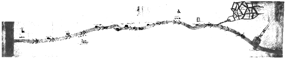
This map is approx 140cm by 30cm and was almost certainly drawn to support the application to Parliament. Technically it has many similarities to the drawings by Andrew Yarranton in his book "England’s improvement by Sea and Land" published in London in 1677. Yarranton was not a skilled artist yet this map is effective in its purpose.
It is important as a historic document connected with the early roots of the industrial revolution, and contains a large amount of documentary information. As a map it does not make any attempt at cartographic accuracy, merely acting to portray the important features along the river which could be served by navigation.
It is no coincidence that nearly all the buildings shown alongside the river have some connection with the iron trade. Yarranton himself was the proprietor of an early blast furnace at Shrawley, on Dick Brook, and needed a cheap transport system to the Black Country, he had already canalised Dick Brook with roman locks.
Most of the buildings shown are forges that could use his iron, and most of them are still in use for other purposes. Two are still operating in the iron trade, Cookley Forge, now "Steel Stampings" manufacturing lorry wheels and Stourbridge Forge as "John Bradley’s". At Cookley a Slitting mill is shown near to the forge. The map is extremely useful in showing that these forges etc existed in the 1660’s. During this period a number of forges and slitting mills on the Stour and its tributary the Smestow were owned by the Foley family, who would like Yarranton have been seeking easier and cheaper methods of transporting iron and coal than by pack-horse and carts.
Two types of boat are shown on the map, large masted vessels on the Severn, presumably meant to be Severn Trows, (just visible on the library copy), and smaller vessels on the Stour are shown also with masts and sails. In fact the Stour river traffic would have almost certainly have been by horse drawn tub-boats, but this map is only supposed to convey a simple large scale impression of Yarranton’s proposals and the connections with industry.
Perhaps of greater significance are two features on this map which do not appear on later maps, and may never have been built. Both these features are important as they are the link between the river and forges and Black Country collieries,
The first is a wharf opposite Barg Hall, which appears to be linked to a "Rail-road" heading into the Black Country. There is no indication as to the exact location but it is possible to examine the area knowing the location of various coal-pits and the topography, and it seems extremely likely that this proposed rail-road would have been close to "Coalbournbrook".
The second feature is a little less clear, and of smaller scale, at first glance a rail-road, but it bares only a partial resemblance to its neighbour, and more importantly shows the land-owners who would be linked to the proposed navigation. It is more easily placed heading towards "Bretell Lane", and would have followed the course of one of the two streams heading through Brochmoor towards Brierley Hill and the Fens.
During the mid 1660’s this area was growing rapidly in importance and was also the area in which Dud Dudley was working with his forges prior to publishing his treatise ‘Metallum Martis’ in 1665 advocating the use of pit-coals for the production of iron.
Nash in his “History of Worcestershire” tells us that Yarranton’s Stour Navigation ran into difficulties and quotes Yarranton himself “The river Stoure and some other rivers were granted by an Act of Parliament to certain persons of honour, and some progress was made in the work, but within a small while after the Act passed it was let fall again. But it being a brat of my own, I was not willing it should be abortive therefore I made offers to perfect it, having a third part of the inheritance to me and my heirs for ever, and we came to an agreement. Upon which I fell on, and made it completely navigable from Stourbridge to Kederminster, and carried down many hundred tuns of coales, and laid out near one thousand pounds, and there it was obstructed for want of money, which by contract was to be paid.”
Yarranton’s Stour Navigation was bitterly opposed and during November 1667 the lock gates at Kidderminster were chained and had to be broken open, to allow the passage of seven barges. Eventually heavy flooding in 1670 destroyed the navigation and it fell into disuse.
Notes
Shirbrige for ‘Stourbridge.’
The Bill must have been the origin of the Act of Parliament which applied both to the Stour and Salwarpe, and is no doubt the statute referred to in the quotation from Yarranton.