| Home | Research Home |

The Staffs & Worcs Canal (1771)

The first canal in the Stour Valley passed to the west of the coal field, opening between Mitton (Stourport) and Wolverhampton in 1771, and to Haywood Junction on the Trent and Mersey Canal in 1772. From Stourport to Stourton the canal closely follows the course of the River Stour, which had itself been made navigable a century earlier by Andrew Yarranton.

During the 1660's Yarranton had proposed a system of navigable Rivers linked by canals serving the English Midlands and Brindley's canal built a centuary later follows the course of Yarranton proposals to link the Severn with the Trent

After Stourton the canal follows the Stour's main tributary, the River Smestow, before leaving the valley just north of Compton.

At a time of increasing industrial development on the coal field the new industries were left still seeking improvements in the transport infrastructure of the region before they could begin to reach their full potential.

The Stourbridge Canal (1779)

| TOP |

The original proposal of 1766 by was surveyed by James Brindley who was surveying the nearby Staffs and Worcs Canal. The proposers included the Earl of Stamford, Thomas Foley & John Hodgetts, and the canal was to link Stourbridge with the Staffs & Worcs at Stourton.

Lord Dudley joined the proposers in 1774, at a time of Land Enclosure Acts across Pensnett Chase on the Coal-field, and a new survey was made by Robert Whitworth. Other colliery owners, iron masters, glass makers etc. had joined the promoters and after a public meeting in Stourbridge in 1775 it was decided the canal should have a branch to Dudley.

The Bill for construction of the canal was opposed in Parliament in the spring of 1775, by the Birmingham Canal Navigation company and mine owners who would not be served by the canal.

The following year Acts for two separate canals were passed by Parliament on the 2nd April 1776, and the Stourbridge Canal was opened in 1779 from Stourton to Stourbridge with branches to Fens Pools on Pensnett Chase and the bottom of Delph Locks where it joined the Dudley Canal.

The Dudley No 1 Canal (1779)

| TOP |

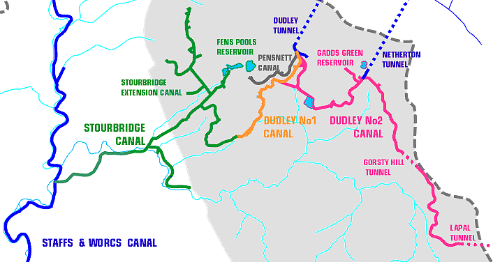
Originally planned as part of the Stourbridge Canal this short 2½ mile canal was owned and built by a separate company, but they shared many committee members and also employees, and so were effectively run as one company. The two canals opened up the coal field and allowed rapid expansion of the collieries and iron works in the area.

During the next two decades the

The Dudley No 2 Canal (1797)

| TOP |

The Pensnett Canal (1840)

| TOP |

With the growing involvement of Lord Ward and his agent Richard Smith, the Dudley Estate began to actively exploit its own mineral wealth. The Pensnett Canal (Lord Ward's Branch Canal) linked the estate collieries on the eastern edge of Pensnett Chase with the Dudley Tunnel and Dudley canals at Park Head. Iron works leased from the Estate were usually obliged to buy some of their coal from Estate collieries.


The Stourbridge Extension Canal (1840)

| TOP |

By the early part of the 19th Centuary the demand by industries for coal was outstripping supply and the development of the western area of the coal field around Shut End and Pensnett was dependant on improved transport links.

Despite proposals in 1820 to build a canal to Shut End, the Shut End (Kingswinford) Railway reached the area first, opening in 1829, and running from Ashwood Basin on the Staffs & Worcs canal. However the railway had been built to take coal out of the Black Country, south to Kidderminster, Stourport and the River Severn.

There was a proposal in 1836 to build a canal from near Fens Pools on the Stourbridge Canal to Bloomfield Junction on the B.C.N., to be known as the Stourbridge, Wolverhampton & Birmingham Junction Canal. This was vigorously opposed by Lord Ward & the other canal companies, and in 1837 an Act was passed for the Stourbridge Extension Canal. This was completed 3 years later and by 1856 served six iron-works as well as numerous collieries.